Have an opinion on what business should go where in Hibbing?
Then plan to attend the upcoming public input session on the future of land use in Hibbing.
The City of Hibbing, along with planning consultant HKGi, will host a Community Open House beginning at 3 p.m. Monday, May 19, in the second-floor conference room at city hall. This event is intended for all Hibbing residents, business owners, and property owners.
The city’s Planning Commission is in the process of updating the Natural Environment chapter of the city’s Comprehensive Plan, which was approved by the city council in 2018. This chapter is focused on analysis and future guidance for all land uses city-wide.
HKGi has been hired to assist with updating the chapter. HKGi has experience with a broad range of cities preparing comprehensive plans, including land use planning.
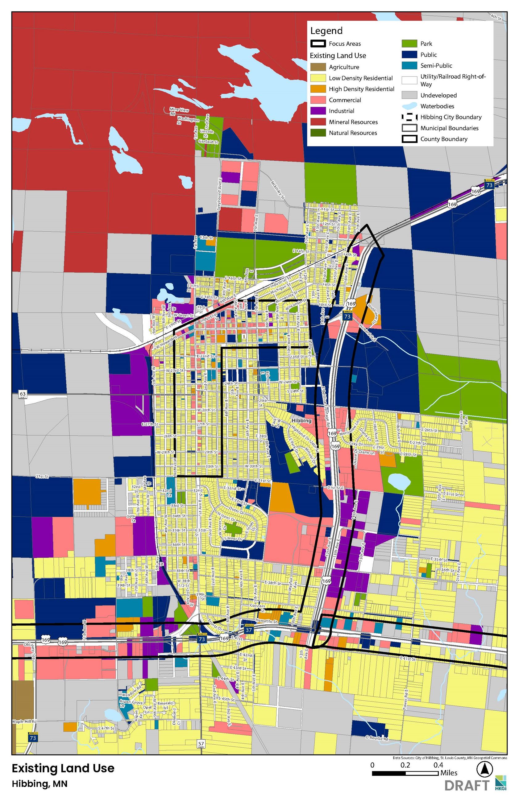
The open house will feature informational displays that describe the basic elements of an effective land use plan; GIS-based land use inventory maps including existing land uses city-wide and three focus areas (downtown, Hwy 169 corridor, Hwy 37 corridor); future projections for population, households, businesses and demand for land; and potential key topics/goals for future land use planning, according to Jeff Miller of HGKi.
“(We aim) to introduce community members to the basic elements of an effective land use plan, present accurate GIS-based land use inventory maps including an existing land use map, and provide an opportunity for questions and input from community members,” said Miller when asked the intent of the open house.
The goals for updating the land use chapter are to add the essential elements of an effective land use plan, develop GIS-based land use inventory maps, identify vacant/potential developable land, and develop a future land use map, according to Miller.
Having a current and future land use map that matches the city council’s community and economic development goals helps pave the way for future business and housing developments to take place, noted Community Development Director Betsy Olivanti.
“Additionally, our GIS maps have not been updated as zoning changes take place so those will be identified as part of this project,” she added. “Finally, the future land use map will inform any updates to the city’s zoning maps, along with permitted and conditional uses within those zones reviewed and revised as needed.”
Community residents who want to have input into the current and future land use within the city should attend the open house. Miller said consultants will be seeking input from community members on several key land use concepts, specifically:
- housing options
- redevelopment needs
- expansion/attraction of businesses
- compatibility between new and existing development
- walkable neighborhoods
- issues/opportunities for future changes and development in the three focus areas (downtown, Hwy 169 corridor, Hwy 37 corridor).
“This project will lead to a zoning map refresh that encourages developments in our city that are in keeping with the council’s vision to move the community forward,” said Olivanti. “Local businesses and others looking to expand their business in Hibbing will be able to look at our zoning map, along with the conditional and permitted uses, and find the right spot in our town to do so.”
Immediately following the Community Open House on Monday, project consultants will meet with the Planning Commission as it is the advisory group for the land use plan update. That meeting begins at 5 p.m.
“Keep in mind that the comprehensive plan, including the existing and future land use maps, are different from the zoning code and the zoning map,” explained Miller. “The comprehensive plan is the city’s big picture, visionary, long-term guide for future land use planning, whereas the zoning code and zoning map provide detailed regulations for at the property level and current development.”
Updates to the land use chapter do not automatically change zoning.
“Cities typically update the zoning code and zoning map following a comprehensive plan update to align zoning with the plan,” Miller continued. “Any changes to zoning will involve a separate process and additional public engagement.”
Additional public engagement will occur in July/August and October/November, including open houses and online input opportunities. The updated land use chapter is anticipated to be completed and adopted into the Comprehensive Plan by the end of 2025.
“This project is one step closer to the key results the council is working towards of long-term financial sustainability and economic vitality,” said Olivanti.
************
A land use chapter in a city’s comprehensive plan typically provides the following elements to guide land use changes and development for the next 10 to 20 years:
- an inventory and mapping of current land uses (e.g. agricultural, residential, commercial, industrial, public, resource extraction, environmental protection);
- analysis of land use trends and issues related to current development patterns and capacity for future development;
- identification and mapping of development constraints (e.g. wetlands, floodplains, steep slopes,
- identification and mapping of potential developable land for growth, intensification, and redevelopment, including access to municipal utilities;
- future projections for population, households, businesses and demand for land to accommodate growth;
- defined future land use classifications and a future land use map
- establish land use goals, policies, and strategies.
Source: HGKi
Visual courtesy of HGKi